


SENTERA sensors and software deliver fast, accurate information that improves outcomes for farmers and corporate growers. SENTERA integrated solutions deliver critical measures of real-time crop performance directly into the key tools that agribusiness professionals use.
From basic imagery, accurate NDVI, and Red Edge products, to the most sophisticated multispectral, thermal, and machine learning technologies, SENTERA gives you cost-effective, high-performance tools to continuously improve your operations, on and off the field.
IATEC Plant Solutions can now share its extensive experience in the application of UAVs to help clients in select, customize, purchase and maintain the entire range of SENTERA products.
SENTERA PHX
With the PHX fixed-wing drone system from SENTERA, effortlessly cover more acres with fewer resources, bringing accuracy and time savings to the field. Easily connect the SENTERA DOUBLE 4K sensor of choice and seamlessly integrate data with FieldAgent® to validate performance and outcomes.

SENTERA PHX
-
Flight time: 59 min;
-
Weight: 2 kg (4.5 lbs);
-
GDS: 3 mm/px;
-
Accuracy: 3 cm;
-
Coverage: 640 ac/h.
Full Integration:
-
DOUBLE 4K;
-
65R;
-
MAVlink;
-
FieldAgent®;
-
SENTERA Senthawk Autopilot;
-
SENTERA PX4 Custom Flight Control Software.
ANATOMY of the SENTERA PHX

FEATURES
Faster Data Collection, More Precise Analytics.
Capture high-resolution imagery with the SENTERA PHX + DOUBLE 4K sensor for key analytics:
-
Canopy Cover;
-
Crop Health;
-
Residue Cover;
-
Tassel Count;
-
Crop Area;
-
Flowering;
-
Stand Count.
APPLICATIONS
-
Agriculture;
-
Construction;
-
Environmental monitoring;
-
Infrastructure.
AGX710
Integrating onto DJI’s industry-leading MATRICE 200 Series industrial drones, the AGX710 sensor provides you with exceptional crop health insights. The AGX710 easily attaches to a DJI M200 or M210 using plug-and-play technology, allowing you to quickly capture crop data and develop high-precision spectral index measurements and run deep learning algorithms.
SENTERA and DJI collaborated to develop the AGX710 gimbaled precision agriculture sensor and Payload SDK in parallel, optimizing both for the benefit of the agriculture industry. Since the AGX710 is powered by DJI SKYPORT, you can get real-time and live-streaming RGB and NDVI measurements that deliver crop health data to support current workflows.

AGX710 key benefits include:
-
Capture relevant health indices, variants include: RGB, NDVI, NDRE, and other specialized index products;
-
Scout fields with live-streaming RGB and NDVI video via LiveNDVI™;
-
Integrated solution — free mobile app to fly and collect data, then analyze using the FieldAgent desktop platform;
-
Generate shapefiles, support prescription development, and telematics integration with FieldAgent;
-
Imagery is compatible with analytics around stand & emergence, biomass, nutrition, pest, weed, & disease.
On M210 dual-gimbal configurations, combine the AGX710 sensor with a ZENMUSE XT to add simultaneous thermal-band collection on the same flight.

AGX710 data is fully compatible with SENTERA FieldAgent™ analytics tools, reporting, and API integrations. Every new AGX710 includes a 12-month subscription to FieldAgent, offering you the best combination of connected and connectionless imaging and analytics capabilities!

6X MULTISPECTRAL
SENTERA 6X MULTISPECTRAL is the latest high-precision agriculture drone sensors in SENTERA line-up.
Designed to meet the most demanding research and data sciences requirements, the 6X M features 5 simultaneously-triggered, precision-filtered 3.2MP global-shutter imagers, and one 20.1MP RGB imager, each with a dedicated, high-quality optical path.

The SENTERA 6X MULTISPECTRAL sensor provides you with cutting-edge crop health insights. The 6X M delivers science-grade multi-band and high-resolution visual band image products via a streamlined, easy-to-use, data processing workflow.
In a single pass, SENTERA 6X MULTISPECTRAL generates the data necessary to produce the most commonly used, highest-value multispectral and visual brand products and analytical insights for seed performance, disease, weed pressure, nutrition, and yield estimation. It features 5 simultaneously triggered, precision-filtered 3.2MP global-shutter imagers, and one 20.1MP RGB imager, each with a dedicated, high-quality optical path. In the aggregate, the sensor produces 8 channels of image data, with fast frame rate performance and high radiometric accuracy.

FEATURES
-
DJI SKYPORT compatible (real-time reading of DJI MATRICE M350, M300, M210 and M200 GPS telemetry);
-
Real-time onboard multi-layer image registration and advanced analytics;
-
Completely configurable image pipeline;
-
Immediate delivery of actionable data;
-
3 frame per second minimum sustained capture rate;
-
MAVlink compatible;
-
Simple integration to drone platforms;
-
Optional ambient color correction;
-
Optimal data products for manipulation and distribution.
The spectral resolution of the 6X MULTISPECTRAL + RGB Sensor

APPLICATIONS
-
Precision Agriculture;
-
Mapping and Cartography;
-
Forest Management;
-
Environmental Studies;
-
Water Resources Management;
-
Scientific Research;
-
Infrastructure Monitoring.
6X THERMAL
SENTERA understands the need for data accuracy, repeatability and ease of use. SENTERA's industry-leading agricultural sensors provide the highest quality data.
You need data you feel confident to discuss and tools you can count on to do it in the field. Built for high radiometric accuracy, the 6X THERMAL provides pixel-level absolute temperature and spectral reflectance measurements.
The 6X THERMAL is radiometrically calibrated, capable of withstanding scientific rigor. The sensor features a 320 x 256 resolution infrared thermal camera, four precision-filtered 3.2MP global thermal imagers, and a 20.1MP RGB image sensor, each with a dedicated, high-quality optical channel. Ensure data fidelity with 6X THERMAL.

-
Maximize Productivity: Light weight, fast capture rate, synchronized image capture, and gimbal allow for faster & longer flights without sacrificing data quality;
-
Ease-of-use: Plug and play integration, rig processing support, time of capture geo-tagging, and large internal storage streamline your Workflow;
-
Easy Integration: 6X THERMAL is already compatible with many popular UAS platforms and is easy to integrate with other systems using the common interfaces and I/O options;
-
Accuracy: Paired with an incident light sensor, calibrated reflectance panel, and gimbal, 6X THERMAL is ready to produce radiometrically Accurate data out of the box.

FEATURES
-
Four 3.2MP global shutter multispectral imagers, one 20MP RGB imager, and one 320 radiometric FLIR Boson imager;
-
Synchronized image capture for all channels, supports rig processing;
-
Full metadata tagging with geolocation and image characteristics;
-
Open and standardized data formats;
-
Incident light sensor and calibrated reflectance panel included;
-
NDAA Compliant;
-
Compatibility: DJI MATRICE M350, M300, M210 and M200.
The spectral resolution of the 6X THERMAL + RGB + THERMAL Sensor

APPLICATIONS
-
Irrigation Management;
-
Plant Disease Detection;
-
Water Management;
-
Inspection;
-
Survey.
DOUBLE 4K
With plug-and-play technology and gimbal stabilization, DOUBLE 4K allows you to easily swap payloads and select from a variety of sensors to optimize your operation. This makes it easy to quickly capture crop data, develop accurate spectral index measurements, and run deep learning algorithms.
Data generated by DOUBLE 4K is fully compatible with SENTERA’s FieldAgent software, allowing you to create crop health maps in QuickTile, merge data, perform analysis, and insert shapefiles (.SHP) into field equipment—all without the need for an internet connection.


Available in 04 versions:
-
DOUBLE 4K: RGB + Precision NDVI;
-
DOUBLE 4K: RGB + Precision NDRE;
-
DOUBLE 4K: Precision NDVI + Precision NDRE;
-
DOUBLE 4K: 5-Band Multispectral.

FEATURES
-
Possible data products include five-band multispectral, NDVI, NDRE, or RGB imagery;
-
Compatible with several drone platforms;
-
Pairs with plug-and-play gimbal for DJI drones;
-
Compatibility: INSPIRE, MATRICE, MAVIC, PHANTOM and SENTERA PHX;
-
Integrates seamlessly with SENTERA FieldAgent.
APPLICATIONS
Precision Agriculture:
-
Management of Planting Areas;
-
Elevation Mapping;
-
Population Analysis;
-
Orthomosaic;
-
Weed Detection and Mapping.
SINGLE SENSOR NDVI/NDRE
With plug-and-play technology and gimbal stabilization, the SINGLE SENSOR NDVI/NDRE allows for easy payload swapping and a wide selection of sensors to enhance your operations. Quickly capture crop data, develop high-precision spectral index measurements, and execute deep learning algorithms.
All data from the SINGLE SENSOR NDVI/NDRE is compatible with SENTERA's FieldAgent software, allowing you to create crop health maps with QuickTile, consolidate your data, perform analyses, and upload shapefiles (.SHP) directly to field equipment.

FEATURES
-
High-Precision Single Sensor: SINGLE SENSORS is designed to capture measurements related to crop health, maturity, and vigor. NDVI and NDRE images are captured via satellite to obtain more accurate data for analysis;
-
Multispectral Images: to obtain more accurate multispectral images than can be captured through satellite imagery, SINGLE SENSORS is the solution;
-
Agronomic Insights from Two Cameras: SINGLE SENSORS are added to the drone while maintaining the functionality of the existing camera to gain deeper agronomic insights with the option to generate NDVI or NDRE maps;
-
Easily Identify Stressed Crops: with the ability to capture Near-Infrared (NIR) data, detect crop health issues earlier with visibility into how plants are reflecting light given their chlorophyll content;
-
Compatibility: MAVIC and PHANTOM.

APPLICATIONS
-
Precision Agriculture.
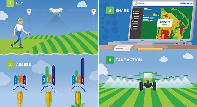
FieldAgent™
FieldAgent™ platform is a complete agricultural data analytics solution that’s with you wherever you are — in the office or in the field. It takes you into meaningful data products with actual economic value, such as NDVI and NDRE zone analysis, population analysis, weed mapping, and elevation & 3D mapping.

FieldAgent™ platform offers a wide range of agricultural analytics products, each with measurable economic value to a growing operation. Each result is available as a data-driven map layer within FieldAgent — visible on your computer, on the web, or on your phone. Results are shareable with clients and advisers, even if they don’t have FieldAgent accounts.
These valuable, field-edge analytic tools are available to all FieldAgent customers, helping ag professionals leverage early-season data for replant decisions, allocate inputs to higher yielding areas, and more-precisely apply chemicals. Providing crop analysis using real-time RGB and NDVI data offers agronomists, crop consultants, and growers expanded field insights before and during growing season.

WEED MAPS
FieldAgent analyzes high-resolution photos to identify weed location and density, generating color-coded maps in the field—no internet connection required. Use these maps to apply chemicals accurately.

PLANT POPULATION MAPS
Get accurate plant counts by area with population tools. Collect high-resolution data and generate color-coded maps in the field, without an internet connection. FieldAgent allows you to map corn, soybeans, potatoes, and other row crops.

SPOT SCOUTING MAPS
Generates analytical maps with grid sampling, achieving more measurements per acre with fewer flights. Increases efficiency by collecting more data per battery compared to manual methods.

FREE STITCHING
With every FieldAgent subscription, enjoy unlimited stitching at no additional cost. Thanks to the collaboration with Open Drone Map, there are no surface, resolution or usage limits. Install the module and stitching starts automatically.

ELEVATION MAPS
Optimize operational efficiency with survey data. Generate prescriptions, drainage plans, and land grading. With FieldAgent, request elevation maps with a click, obtaining topographic images and standard shape files. Improve drainage design and surface water management.

DATA ANALYSIS WITH NDVI TOOLBOX®
FieldAgent makes it easy to identify stressed areas in crops and optimize input application. With NDVI Toolbox, adjust NDVI ranges to model crop health and generate prescriptions. Easily export data to agricultural tools like John Deere and FieldView.
*SELF-SERVICE store is for BRAZIL clients only. US clients must contact us through contact@iatecps.com for pricing and delivery conditions.