


SOARABILITY develops groundbreaking technologies that enable aerial and ground vehicles to accurately collect, analyze and visualize hyper-local air pollutant information, supporting decision makings by governments, organizations, research groups, and individuals alike.
IATEC Plant Solutions can now share its extensive experience in the application of UAVs to help clients select, customize, purchase and maintain the entire range of SOARABILITY products.

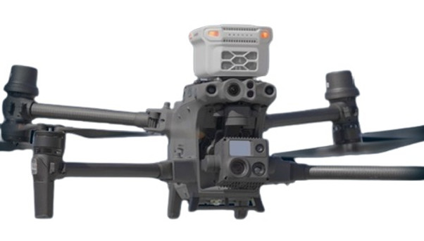
Sniffer4D V2
Sniffer4D consists of a multi-gas detection hardware and powerful analytic software. This system is able to measure and visualize real-time 3D gas concentration distributions. By providing timely & actionable information, Sniffer4D helps first responders, oil & gas industry, environmental agencies, and researchers improve work efficiency, mitigate risks, and reduce costs.
Designed to be carried by drones & ground vehicles Captures geo-referenced & time-stamped gas & particle concentration.
Support integration with DJI M300, Mavic3, M210, M600 and other UAVs. You can upgrade your Sniffer4D V1 into Sniffer4D V2.
FEATURES
-
Up to 9 Parameters at a Time;
-
Verified Data Quality;
-
Cellular Connectivity;
-
Plug & Play;
-
Front & Back Warning Lights;
-
Ultra-short Warm-up Time;
-
Expansion Ports;
-
API;
-
OTA Update;
-
Single Workflow.


APPLICATIONS
-
Hyper-local Environmental Monitoring: Quickly scan through an area and obtain its hyper-local air pollution distribution in 3D. The results can be used to pin down exact locations of suspected fugitive emission sources, to understand how air pollution are transported, and so on.
-
HAZMAT Response: In an event of an emergency, before putting the health and safety of your team at risk, fly Sniffer4D into the scene to quickly identify the types and spreads of toxic gases, and define a safety perimeter.
-
Leak Detection: Efficiently gather distribution information of certain gases in oil & gas plants. Use the information to locate suspected leakage spots, and to identify the spread of harmful substances.
-
Ship Emission & FSC Monitoring: Fly Sniffer4D into ship plumes and it can automatically estimate the Fuel Sulfur Content (FSC) of the ships using its built-in inversion algorithm.


SPECIFICATIONS
-
Size: 157 x 103 x 87mm;
-
Weight: 400 - 500g;
-
IPX2 Rated;
-
Cellular Connectivity;
-
Ex-proof Certification;
-
Ex Ib ⅡC T5 Gb;
-
Anti-EMI Aluminum Casing;
-
Built-in 4G/3G/EDGE/GPRS Connectivity;
-
Internal Suspension Mechanism;
-
Active Air Intake;
-
Data Retrieval Algorithm;
-
Automatic Data Backup in the SD Card.

Sniffer4D Mini2
Sniffer4D Mini2 consists of a compact yet powerful multi-gas detection hardware, and user-friendly analytic software. This system can measure and visualize real-time 3D gas concentration distributions. By providing timely & actionable information, Sniffer4D Mini2 helps first responders, oil & gas industry, environmental protection agencies, and researchers improve efficiency, mitigate risks, and reduce costs.
Support integration with DJI M30 series and DJI Dock. Sniffer4D Mini2's all-new industrial and structural designs bring significant reduction in its size and weight, maximizing M30's flight time. The new quick-release mount and cable connection, shorten the operation preparation time even further.
SPECIFICATIONS
-
Size: 102x103x72mm;
-
Weight: 250 - 300g;
-
Active air intake;
-
Built-in 4G/3G/EDGE/GPRS;
-
Data retrieval algorithm;
-
SD card data storage;
-
DJI Cloud API;
-
Plug the cable to the PSDK port on the top of DJI M30;
-
6 status LEDs;
-
3 warning lights. They change color under different gas concentrations, notifying nearby people about the risks.
Sniffer4D Mapper
O Sniffer4D can detect multiple air pollutants and send data to Sniffer4D Mapper Analytic Software (Windows and Android) in real time, turning air pollution data into intuitive and actionable information.
Sniffer4D Mapper software visualizes and analyzes data from one or multiple Sniffer4D(s) in real time, providing intuitive and insightful information for decision makers.
Target Setting and Navigation: Both on-site and off-site personnel can set a target in Sniffer4D Mapper. The direction and distance to the target will be displayed on the DJI Pilot, and the information will navigate the flight for the pilot, minimizing the information gap between crews.


Automatic Data Forwarding to Cloud: Sniffer4D supports real-time data outputting to the specific software platform required by the user (through the MQTT protocol).
One-click Result Delivery: After a mission, simply click a button to generate a mission report containing key results, or a CSV file containing all the raw data. Reporting your work has never been easier.


MORE SOFTWARE FEATURES
-
Display real-time gas concentration values and temporal graphs;
-
Display Sniffer4D's working status (e.g. GPS satellite number, a latitude);
-
Automatically retrieve data collected by Sniffer4D during communication interruption back to the software;
-
Display real-time video feed from drone;
-
Support connecting to multiple Sniffer4Ds at the same time;
-
Display real-time UAS camera view;
-
Support screen recording during missions;
-
Calculate estimated Fuel Sulfer Content (FSC);
-
Import historical mission files;
-
Import & display orthophoto;
-
Import geo-tagged photos;
-
Calibrate Sniffer4D;
-
Show demo missions;
-
Automatic update.

Sniffer4D TDLAS

Sniffer4D TDLAS Methane Sensing Module supports achieving quantitative methane detection at 1 ppm resolution. It delivers the best resolution &minimum detection limit in its class in terms of size and weight, further reducing routine data collection costs for oil &gas, HAZMAT response, and carbon detection applications. Meanwhile, the advanced real-time data visualization and analytical software provide intuitive & insightful information for decision makers.
Expand the capabilities of your M300 gas detection system with the TDLAS methane detection module. This module provides accurate detection information in real time, allowing for quick response and decision making.


FEATURES
-
Response to Methane within Seconds 1ppm, Ultra-high Detection Resolution;
-
Conforming to GBT33672-2017;
-
Advanced real-time data visualization and analytical software;
-
Real-time intuitive & insightful information for decision-making;
-
Integrates seamlessly with Sniffer4D Mapper to produce 2D and 3D mapping visualizations.
SPECIFICATIONS
-
Size: 109x103x73mm;
-
Weight: 250 - 300g;
-
Resolution: 1ppm (Static Noise Level < 300ppb);
-
Range: 0 ~ 15000ppm;
-
Detection Limit: 1~1.5ppm;
-
Ideal Operate Temperature: 15°~25°.
APPLICATIONS
-
Pipeline Inspection;
-
Carbon Emission Monitoring;
-
HAZMAT Response;
-
Landfill Inspection.

SPEEDIP
Speedip is na inteligente system specially designed for drone-based BVLOS water sampling. It provides large water sampling volume, powerful situational awareness and a variety of user-friendly functions. Speedip aims to help users improve efficiency and reduce cost in sampling point navigation, water sample collection at designated depths, data logging, and work reporting, etc.
FEATURES
-
Fully Autonomous Waypoint Water Sampling Mission: Speedip V2 supports fully autonomous water sampling mission using DJI Pilot’s Waypoint Function;
-
Rope Tangling Detection Mechanism: Automatically stops and warns the operator when the rope is about to tangle, minimizing the possibility of irreversible tangling;
-
Emergency Releasing Function: Cuts the rope to free up the UAV to minimize loss when the container gets trapped;
-
Built-in Downward Facing Camera: Starlight level performance, better situational awareness;
-
Built-in 180° Night Vision Camera: Starlight level performance;
-
Grounding Detection: Avoids & notifies about invalid sampling;
-
Ultra-lightweight Design: Main body weights only 540g, thanks to the use of magnesium alloy;
-
Built-in High-resolution mm-wave Radar: 1mm ultra-high resolution, accurately measuring water distance and container depth;
-
Mission Synchronization in the Cloud: Mission data logging & reviewing;
-
New Smart Motion Control Logic: Adjusts the container’s movement speed based on the sampling stage, resulting in more representative water samples;
-
2L Max. Sampling Volume: Total weight including 2kg water is only ~2.7kg , Within the max. payload limit of DJI M350 RTK;
-
Mounting & Dismounting within 10s: When integrated with DJI M350 RTK/M300 RTK;
-
Multi-ends collaboration: DJI Pilot and Browser.
APPLICATIONS
-
Environmental Protection: Remote Water Sampling in Lakes and Rivers;
-
HAZMAT Response: Corrosive/Contaminative Liquids Sampling;
-
Maritime Affairs: Water & Oil Leak Sampling at Sea.
