


MERIDIAN GNSS provides state-of-the-art GNSS positioning equipment designed to ensure high accuracy, robustness, and versatility in professional applications. Its systems cater to applications ranging from field operations to advanced integrations with UAVs, robotics, and mobile platforms.
IATEC Plant Solutions can now leverage its extensive experience in UAV applications, surveying, and geotechnologies to assist in the selection, customization, purchase, and maintenance of MERIDIAN GNSS's full line of GNSS receivers, data collectors, and high-precision positioning solutions.
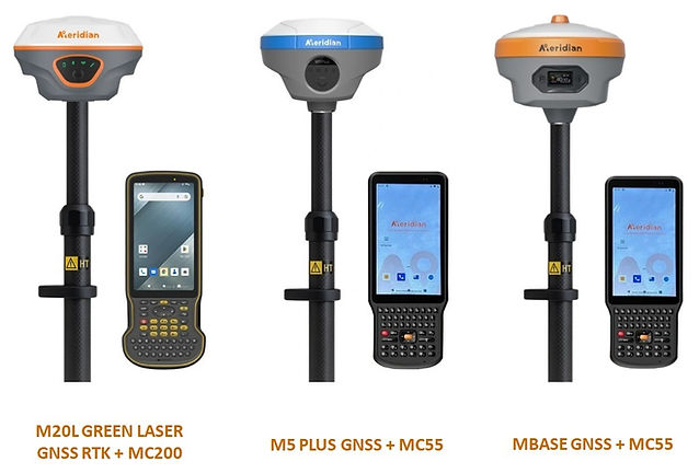
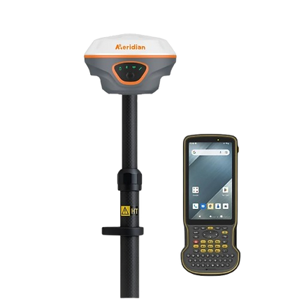
M20L Laser GNSS RTK + MC200
High-precision surveying with laser technology and robust data collection.
The integrated MERIDIAN M20L + MC200 combines a GNSS RTK receiver with a long-range green laser and an industrial data collector running Android 12, delivering accurate measurements without the need for a pole and reliable performance in demanding environments.
KEY HIGHLIGHTS:
-
High-precision green laser: up to 100 m range for reliable measurements.
-
120° calibrated IMU: no calibration required, with automatic tilt compensation.
-
Simplified data collection: MC200 with an intuitive interface, built for field use.
-
Full integration: M20L and MC200 synchronized to streamline surveying and reduce errors.
-
Portability and durability: lightweight, easy to transport, and resistant to harsh conditions.
TECHNICAL SPECIFICATIONS
Technical Specifications – M20L GREEN LASER
-
RTK Accuracy (RMS): Horizontal ±(8 mm + 1 ppm) | Vertical ±(15 mm + 1 ppm);
-
Static Accuracy (RMS): Horizontal ±(2.5 mm + 0.5 ppm) | Vertical ±(5 mm + 0.5 ppm);
-
Laser Accuracy: Horizontal ±(8 mm + 3 mm/m) | Vertical ±(15 mm + 3 mm/m);
-
Data Update Rate: up to 20 Hz;
-
Operating Range: -40°C to +85°C.
Technical Specifications – MC200
-
System: Android 12 with GMS;
-
CPU: Qualcomm SDM 662 octa-core 2.0 GHz;
-
Memory: 4 GB RAM + 64 GB Flash (expandable up to 128 GB);
-
Display: 5.5” IPS Full HD (1920 × 1080), 500 nits;
-
Camera: 13 MP with autofocus and flash;
-
Weight: 420 g;
-
Operating Temperature: -20°C to +65°C.
APPLICATIONS
-
Topographic surveys and terrain mapping;
-
Engineering and construction: level control, alignment, and site measurements;
-
Precision agriculture: planting planning and terrain analysis;
-
Infrastructure and energy projects: environmental monitoring, power lines, and civil works.
Differentiators: RTK + Green Laser Accuracy, simplified data collection with the MC200, and reliable operation in harsh conditions.

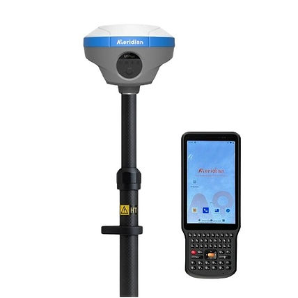
M5 Plus GNSS + MC55
Integrated solution for centimeter-level surveying and robust data collection.
The MERIDIAN M5 Plus GNSS + MC55 integrated solution combines an ultra-light, high-performance multi-constellation GNSS RTK receiver with an industrial-grade Android handheld controller, delivering reliable centimeter-level positioning, long-lasting operation, and optimized field workflows even under demanding conditions.
KEY HIGHLIGHTS:
-
High-precision RTK: multi-channel engine supporting GPS, GLONASS, BeiDou, Galileo, QZSS, IRNSS, and L-Band.
-
120° calibration-free IMU: automatic tilt compensation for hard-to-reach locations.
-
Extended battery life: up to 26 hours of operation with fast charging.
-
Robust MC55 controller: Android 11, octa-core processor, full physical keyboard, and multi-touch display.
-
Durability: both devices feature IP67 protection and drop resistance.
TECHNICAL SPECIFICATIONS
Technical Specifications – M5 Plus GNSS
-
Constellations: GPS, GLONASS, BeiDou, Galileo, QZSS, IRNSS, L-Band;
-
IMU: 120°, calibration-free;
-
Internal storage: 8 GB;
-
Battery: 7.4 V 7000 mAh, up to 26 h, quick charge;
-
Protection: IP67;
-
Compact design: palm-sized, lightweight;
-
Operating temperature: -40°C to +85°C.
Technical Specifications – MC55
-
OS: Android 11;
-
CPU: MTK6762V octa-core, up to 2.0 GHz;
-
Display: 720 × 1440 px, full-view laminated, capacitive multi-touch;
-
Keyboard: 51 physical keys + side custom key;
-
Camera: 13 MP;
-
Connectivity: GSM, WCDMA, TD-SCDMA, FDD-LTE, TDD-LTE (4G support);
-
Battery: 6600 mAh;
-
Protection: IP67, 1.2 m drop resistant;
-
Operating Temperature: -20°C to +50°C | Storage: -40°C to +80°C.
APPLICATIONS
-
Topographic surveys and terrain mapping;
-
Engineering and construction: leveling, alignment, and site measurements;
-
Precision agriculture: planting planning and soil analysis;
-
Infrastructure and energy projects: environmental monitoring, power lines, and civil works.
Differentiators: the M5 Plus GNSS + MC55 integrated solution ensures reliable centimeter-level accuracy, continuous operation, and efficient data collection, making it ideal for professionals requiring mobility, ruggedness, and consistent results in the field.
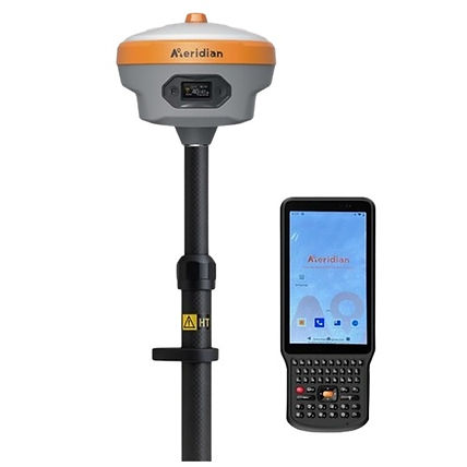
MBASE GNSS + MC55
Integrated Solution for High-Performance GNSS RTK Surveying.
The MERIDIAN MBASE GNSS + MC55 integrated solution combines a professional-grade GNSS base receiver with a rugged industrial Android data collector, providing reliable RTK coverage, continuous operation, and optimized workflow in the field, even under harsh conditions.
KEY HIGHLIGHTS:
-
High RTK Accuracy: 5W integrated radio with up to 35 km range, ensuring reliable base and rover operations.
-
Advanced Tilt IMU: fast and accurate measurements without leveling, supporting up to 60° tilt with 2 cm precision.
-
Highly Integrated Four-in-One Antenna: optimizes performance and reliability, reduces failure rates, and increases measurement efficiency.
-
Full Connectivity: 4G, Wi-Fi, and Bluetooth for fast data transfer and easy synchronization with MC55.
-
Robust MC55 Controller: Android system, intuitive operation, multi-touch screen, and high durability in the field.
-
Lightweight, Compact & Rugged Design: both devices are easy to transport, quick to set up, and built for harsh environments.
TECHNICAL SPECIFICATIONS
Technical Specifications – MBASE GNSS
-
GNSS Constellations: GPS, GLONASS, BeiDou, Galileo, QZSS, IRNSS, L-Band (depending on configuration);
-
IMU: Tilt up to 60°, calibration-free, 2 cm accuracy;
-
Internal storage: 8 GB;
-
Battery: 7.4 V, 7000 mAh, continuous operation up to 26 h, fast charging;
-
Protection: IP67, dust and water resistant;
-
Design: compact, lightweight, and rugged, ideal for transport and field operations;
-
Operating temperature: -40°C to +85°C;
-
Transmission Radio: 5 W, range up to 35 km under ideal conditions;
-
Connectivity: 4G, Wi-Fi, Bluetooth, integrated UHF radio.
Technical Specifications – MC55
-
OS: Android 11;
-
CPU: MTK6762V octa-core, up to 2.0 GHz;
-
Display: 720 × 1440 px, full-view laminated, capacitive multi-touch;
-
Keyboard: 51 physical keys + side custom key;
-
Camera: 13 MP;
-
Connectivity: GSM, WCDMA, TD-SCDMA, FDD-LTE, TDD-LTE (4G support);
-
Battery: 6600 mAh;
-
Protection: IP67, 1.2 m drop resistant;
-
Operating Temperature: -20°C to +50°C | Storage: -40°C to +80°C.
APPLICATIONS
-
Topographic surveys and land mapping: precise and fast measurements in any environment;
-
Engineering and construction: leveling, alignment, and on-site project monitoring;
-
Precision agriculture: crop planning, soil analysis, and field monitoring;
-
Infrastructure and energy projects: inspection and monitoring of transmission lines, roads, railways, and civil works.
Differentiators: the MBASE GNSS + MC55 integrated solution provides reliable RTK coverage, continuous operation, and efficient data collection, making it ideal for professionals who need mobility, ruggedness, and consistent results in the field.
*SELF-SERVICE store is for BRAZIL clients only. US clients must contact us through contact@iatecps.com for pricing and delivery conditions.