


SPH Engineering is a provider of UAV software solutions, integration services, consulting, and custom development for the drone industry.
Its innovations support UAVs of different manufacturers and advance drone technologies for surveying, data collection, and entertainment.
Founded in 2013 in Latvia (EU), the company has a global customer and partner network in 150+ countries, in a wide range of areas including environmental, archeological, engineering & mining, agricultural and biological.
The company maintains 04 business lines:
-
UgCS - mission planning and flight control software technology;
-
UgCS Integrated Systems - airborne integrated systems with sensors from diverse manufacturers;
-
Drone Show Software - a technology to manage drone swarm flights;
-
SPH Consulting & Development - knowledge-based services to implement, integrate and develop technologies for the drone industry.
IATEC Plant Solutions can now share its vast experience in the application of UAVs to help its customers select, customize, purchase and maintain the entire range of SPH Engineering products - UgCS and UgCS Integrated Systems.
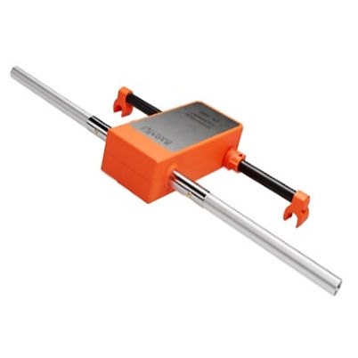
RADAR SYSTEMS ZOND AERO LF
The ZOND AERO LF is an ultra-lightweight, low-frequency Ground Penetrating Radar (GPR) system designed for deep subsurface investigations in geophysical, archaeological, and engineering applications. With antenna options ranging from 50 to 400 MHz and real-time sampling (RTS) technology, it delivers high-quality data with excellent signal-to-noise ratio. Its modular, customizable design ensures outstanding versatility for aerial operations.

Drone Compatibility:
-
Mounting brackets for DJI MATRICE 300 RTK and MATRICE 350 RTK;
-
Brackets for other drone models available upon request*;
-
*Requires additional components and software for drone operation;
-
*Full system bundle recommended for complete functionality.
FEATURES
-
Lightweight, compact GPR optimized for drone integration;
-
Three standard frequencies: 300, 150, and 100 MHz with interchangeable dipoles*;
-
Extended frequency range: 50–400 MHz available on request*;
-
Custom-tunable dipoles: trim supplied dipoles to achieve desired central frequency;
-
High-resolution data: RTS with hardware stacking and low noise.
TECHNICAL SPECIFICATIONS
-
Type: Single-channel GPR with unshielded dipole antenna;
-
Center Frequencies: 100 / 150 / 300 MHz (others between 50–400 MHz on request);
-
Bandwidth: Up to 150–600 MHz (-12 dB);
-
Depth: Up to 12 m in soil with εr = 5, attenuation up to 5 dB/m;
-
Sampling Rate: Up to 1,280,000 samples/s;
-
Sweep Rate: Up to 2,500 sweeps/s;
-
Samples per Sweep: 256 to 8192 (selectable);
-
Temporal Resolution: 18 ps to 2.5 ns (selectable);
-
Data Format: SEGY (.sgy), geocoded;
-
Total Weight:
-
Controller: 0.8 kg;
-
Antennas: 0.1 to 0.4 kg.
-
-
Size (Controller): 23 × 25 × 5.5 cm;
-
Power: Powered by the drone's battery;
-
Environmental: -20°C to 60°C - Humidity 96% without condensation;
-
Protection: IP68 (transport), IP52 (flight).
APPLICATIONS
-
Engineering;
-
Archaeology;
-
Hydrology;
-
Geophysics;
-
Meteorology.
*Consult us to learn more about: sensors and optional tools.
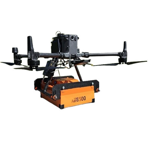
RADAR SYSTEMS ZOND AERO 500 NG
The ZOND AERO 500 NG is a lightweight and highly versatile Ground Penetrating Radar (GPR) system designed for both ground-based and aerial surveys across diverse environments. Featuring real-time sampling (RTS) and advanced digital signal processing, it delivers high-quality data with an excellent signal-to-noise ratio. Its modular design supports multiple operating modes, making it adaptable to a wide range of field conditions.
Drone Compatibility:
-
Supports DJI MATRICE 300 RTK and MATRICE 350 RTK;
-
Suitable for medium-class drones with high payload capacity;
-
*Additional components and software required for aerial use;
-
*Full system bundle recommended for optimal performance.
FEATURES
-
Universal GPR system: for ground and drone-based operations;
-
RTS and integrated digital processing: for high-resolution, low-noise data;
-
Lightweight and portable: optimized for field deployment;
-
Multiple operating modes:
-
Mounted on a wheeled cart, ideal for streets and confined spaces;
-
Towed manually with a rope for uneven terrain;
-
Drone-mounted, suitable for large, open areas free of tall obstacles and vegetation.
-

TECHNICAL SPECIFICATIONS
-
Type: Single-channel GPR with shielded antenna;
-
Center Frequency: 500 MHz;
-
Operating Bandwidth: 200–900 MHz (-12 dB);
-
Detection Depth: Up to 4 m (normal ground, 100 ns window);
-
Sampling: Real-time (RTS), hardware stacking;
-
Sampling Rate: Up to 1,280,000 samples/s;
-
Sweep Rate: Up to 2,500 scans/s;
-
Samples per Scan: 256 to 8,192 (selectable);
-
Temporal Interval: 71 ps to 1 ns (selectable);
-
Data Format: SEGY (.sgy), 32-bit, with geocoding;
-
Power:
-
Aerial: Uses the drone's battery (via payload connector);
-
Ground: Internal 99 Wh battery, up to 12 hours of operation.
-
-
Protection: IP68 (transport/ground) / IP52 (air mode);
-
Operating Temperature: -20°C to 60°C;
-
Humidity: up to 96%;
-
Weight: 2.1 kg;
-
Dimensions: 41 × 31 × 16 cm;
APPLICATIONS
-
Utility research;
-
Underground infrastructure mapping;
-
Archaeology;
-
Geotechnical surveys;
-
Geological stratigraphy;
-
Glaciology, snow/ice thickness profiling.
*Additional components and software must be ordered to use this GPR with drones. It is recommended to order the complete set.
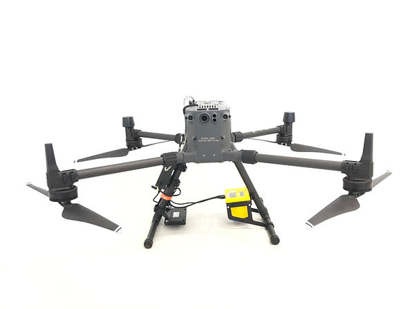
ECHO-SOUNDER
The ECHO-SOUNDER is an integrated airborne bathymetric survey system that combines precision, efficiency, and safety. Mounted on medium-sized drones, it enables the collection of high-quality bathymetric data in shallow, remote, or hazardous environments - without the need for direct water contact. With fast deployment and remote operation, it is up to 10 times more efficient and twice as cost-effective as traditional methods.

Drone Compatibility:
-
Supports DJI MATRICE 300 RTK and MATRICE 350 RTK;
-
Designed for medium-class UAVs capable of carrying hydrographic sensors;
-
*Configurable with various drone models and platforms;
-
*Requires compatible mission planning software, such as UgCS.
FEATURES
-
Accurate aerial bathymetric surveys: including shallow and coastal waters;
-
Quick deployment: no water access point required;
-
Highly efficient: up to 10x faster than conventional survey methods;
-
Cost-effective: operation is 2x more economical;
-
Enhanced safety: ideal for inaccessible or hazardous locations;
-
High measurement precision: constant-speed, low-altitude drone flights;
-
Modular sensor options: selected based on environmental conditions;
-
*The ECHO-SOUNDER system from UgCS (SPH Engineering) for aerial bathymetry with drones has three versions: ECT D052S, ECT D24S and ECT 400S.

TECHNICAL SPECIFICATIONS
-
Type: Drone-integrated airborne bathymetry system;
-
Manufacturer: Radar Systems / Distribuidor: UgCS;
-
Available Models*:
-
*ECT D052S (50/200 kHz) – Dual-frequency;
-
*ECT D24S (200/450 kHz) – Dual-frequency;
-
*ECT 400S (450 kHz) – Single-frequency.
-
-
Sensors: Echologger ECT Series;
-
Frequency: According to model (see above);
-
Sensor Weight: 1.3 to 1.85 kg (depending on model);
-
Total Drone Payload Weight: ~8.9 kg (including altimeter, SkyHub, mounts, cables);
-
Depth Range: Up to 100 m (depending on frequency and water turbidity);
-
Accuracy: High precision with GNSS correction and laser altimeter;
-
Sampling: Synchronized with GPS (SkyHub), georeferenced bathymetric data;
-
Data Format: NMEA, CSV, GIS-compatible formats;
-
Power Supply:
-
From drone (DJI M350/M300 RTK) via payload connector;
-
Optimized component power via SkyHub.
-
-
Protection Rating: IP67 (sensor);
-
Operating Temperature: -10°C to 50°C / Relative Humidity: up to 95%
APPLICATIONS
-
Water depth mapping in lakes, rivers, canals, and lagoons;
-
Sediment assessment before dredging;
-
Scientific and environmental monitoring;
-
Underwater inspections of engineering structures;
-
Floodplain and containment basin mapping.
*Additional components and software must be purchased to use this sensor with drones. A complete set of required items will be provided when you request a quote.
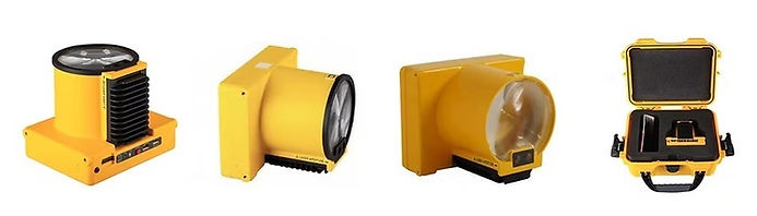
LASER FALCON - Methane Detector
LASER FALCON + Drone-based remote methane leak detector.
Real-time data at your fingertips.
Use remote methane detector + drone integrated system for natural gas pipeline surveys, tank inspections, landfill emission monitoring, gas well testing, and plant safety audits.
Drone Compatibility:
-
Supports DJI MATRICE 300 RTK and MATRICE 350 RTK;
-
Designed for medium-class UAVs capable of carrying hydrographic sensors;
-
*Configurable with various drone models and platforms;
-
*Requires compatible mission planning software, such as UgCS.
FEATURES
-
Efficiency: Outperforms foot search by 5x times;
-
Accuracy: Detected leaks are referenced to GPS coordinates (high fidelity RTK GPS is also supported);
-
Increased safety: Applicable at unsafe and hazardous environments without compromising the safety of staff or equipment;
-
Automation: Fully automated and repeatable surveys;
-
Precision: The FALCON LASER Methane Detector is sensitive only to methane, so no false readings of other gases are possible;
-
Reporting: Fully automated reporting.
TECHNICAL SPECIFICATIONS
-
Weight: 1 kg;
-
Dimensions: 210 × 210 × 150 mm;
-
Detection Technology: Laser in the 1.65 μm spectral range (near-infrared);
-
Detection Range: 1 to 50,000 ppm·m within 20 meters;
-
Data Transmission Range: Up to 5 km;
-
Survey Rate:
-
Flight time: up to 25 minutes;
-
Area coverage: up to 5 times larger than on-foot inspections.
-
-
Mission Planning Compatibility:
-
Integrated with UgCS 3D mapping software;
-
Supports terrain-following flight missions;
-
Compatible with UgCS SkyHub and altimeter for True Terrain Following mode.
-
-
Camera Integration: Compatible with DJI H20 and H20T cameras for simultaneous visual and thermal inspections.
APPLICATIONS
-
Dairy industry;
-
Landfill industry;
-
Air quality compliance by Environmental Consulting Firms;
-
Leak Detection and Repair Service Companies;
-
Drone service providers;
-
Oil and gas suppliers.
*Additional components and software must be purchased to use this sensor with drones. A complete set of required items will be provided when you request a quote.
SKYHUB V.3
The UgCS SKYHUB V.3 is an onboard computer developed to extend the capabilities of commercial drones by enabling advanced sensor integration and the execution of industrial missions in demanding environments. Designed for professionals who require precise control and georeferenced data collection, the SKYHUB V.3 offers:
-
Custom payload integration with drones;
-
Execution of complex flight control scenarios;
-
Reliable operation in adverse environments;
-
Geotagged data logging from sensors such as GPR, altimeter, magnetometer, and methane detectors.
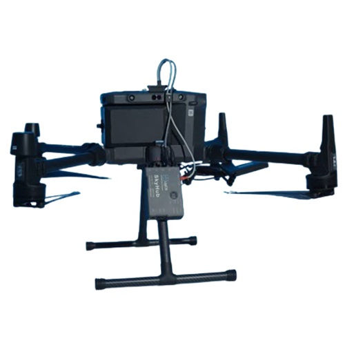
Drone Compatibility:
-
Supports DJI MATRICE 300 RTK and MATRICE 350 RTK;
-
Designed for medium-class UAVs capable of carrying hydrographic sensors;
-
*Configurable with various drone models and platforms;
-
*Requires compatible mission planning software, such as UgCS (Universal Ground Control Software);
-
*SKYHUB V.3 is not intended for standalone use, as its functionality relies on integration with specific sensor kits and mission software.
FEATURES
-
Fully isolated and ESD-protected external interfaces;
-
Reliable and convenient connectors with lock, ideal for airborne applications;
-
Selectable power output (9 V / 12 V / 15 V /18 V) with switch-off function for payload connecting;
-
Drone power pass-through to external payloads;
-
3× UART / 1x RS-232 / 1x UART/RS-232 combined / 2× USB / Ethernet / Wi-Fi / Bluetooth interfaces;
-
4x GPIO pin pairs for general purpose input/output;
-
Protection against input power’s inverse polarity;
-
Extended operating temperature range from −25°C to 50°C.

APPLICATIONS
-
Typical Applications;
-
Underground mapping with GPR;
-
Natural gas and methane leak detection;
-
Magnetic and geophysical surveys;
-
Terrain-adapted missions using True Terrain Following mode.
*Additional components and software must be purchased to use this sensor with drones. A complete set of required items will be provided when you request a quote.
UgCS PRO
UgCS PRO - Drone Flight Planning and Control Software by SPH Engineering.
APPLICATIONS AND SPECIFICATIONS
-
PHOTOGRAMMETRY:
-
VERTICAL SCAN:
-
GEOTAGGED VIDEO STREAMING:
-
POWERLINE INSPECTIONS:
-
LIDAR:
-
MAGNETIC AND OTHER LOW ALTITUDE SURVEYS:
-
PV SOLAR PANEL INSPECTIONS:
-
GRP-DRONE SURVEYS:
%20-%20UAV%20M200%20M210%20M300%20M600.png)
-
SYNCHRONIZED MULTI-DRONE MANAGENENT AND CONTROL:
%20-%20UAV%20M200%20M210%20M300%20M600.jpg)
*SELF-SERVICE store is for BRAZIL clients only. US clients must contact us through contact@iatecps.com for pricing and delivery conditions.